KGS researchers receive funding from the U.S. Geological Survey's National Earthquake Hazards Reduction Program

KGS researchers Seth Carpenter and Zhenming Wang, along with Edward Woolery, KGS researcher and chair of UK's Department of Earth and Environmental Sciences, received $64,462 in funding from the U.S. Geological Survey's National Earthquake Hazards Reduction Program. Their project, "Improving Estimates of Ground-Motion Site Response in the New Madrid and Wabash Valley Seismic Zones," will provide a detailed analysis of the primary parameters that quantify site response at 12 seismic stations in the New Madrid and Wabash Valley Seismic Zones. Site response occurs when seismic waves are modified by shallow geologic layers and can result in additional damage from strong earthquakes.
Carpenter, who is leading the project, says, "Currently, the primary factors used to quantify site response do not account for the effects of seismic wave resonance. Resonance can dominate site response, particularly at sites where there are large property contrasts between the shallowest sediment layers and the deeper bedrock layers, such as in river valleys and sediment-filled basins. This research will assess physics-based parameters that account for resonance, which we anticipate will provide accurate and simple alternatives to the statistics-based factors currently in use."
The goal of NEHRP is to mitigate earthquake losses, which can occur in many parts of the nation, by providing earth science data and assessments essential for land-use planning, engineering design, and emergency preparedness decisions. Funding from NEHRP is competitive, and in 2020, 213 proposals were reviewed and 72 were funded.
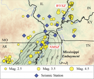
The figure below shows the project study area, with seismic stations that will be used in the study (diamonds) along with epicenters of previous seismic events (circles). Seismic activity associated with the New Madrid and Wabash Valley Seismic Zones are labeled NMSZ and WBSZ, respectively. A significant geologic feature is the sediment-filled Mississippi Embayment, which is indicated by the contours of sediment thickness (in meters) on the figure.


